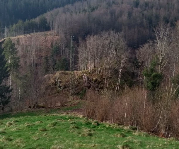
 Altenstein castle site: View from the south towards the Angenbach valley. Deep neck ditch behind the electricity pylon, with the castle grounds behind it. Remains of the southern curtain wall in the visible ridge on the castle grounds. Foto: Wolfgang Richter
 Remains of the southern curtain wall. Foto: Wolfgang Richter
The castle ruins
The castle site of the Altenstein ruins is located not far from the hamlet of Altenstein in the municipality of Häg-Ehrsberg on a mountain spur that extends into the Angenbach valley. On the south side, the mountain spur is separated by an approx. 8 m deep neck ditch; on the west, north and east sides, the mountain spur falls almost vertically into the Angenbach valley (Bigott 2009). There are small remains of a curtain wall along the ditch (Meyer 1981). The castle area has probably partially slipped into the Angenbach valley.
History
The castle was probably built in the 12th or 13th century. Nothing is known about the end of the castle.
It is unclear whether it is the documented Altenstein Castle, the presumed ancestral seat of the Lords of Stein. Based on the existing documents from the 14th century and other evidence, Schubring assumes that it is the documented Altenstein Castle (Schubring 2012). Meyer and Bigott, on the other hand, assume that the documented Altenstein Castle is the Henschenberg ruins near Zell im Wiesental (Bigott 2009, Meyer 1981) (see also Henschenberg ruins).
Altenstein Castle, which is mentioned in a document, was probably only called Stein at first. After Neuenstein Castle was built by the lords of Stein, it was called Altenstein to differentiate it from Neuenstein Castle. Neuenstein Castle was first mentioned in 1283. Altenstein Castle must therefore have already existed in the second half of the 13th century. Altenstein was presumably an official castle of Säckingen Abbey, which was given as a fief to the Lords of Stein as the abbey's masters and served as an administrative centre (Gutmann 2013). According to a document from 1421, it had evidently lost its function as an administrative centre by this time (Gutmann 2013).
Getting there by 🚗 and by 🥾
From 79685 Häg-Ehrsberg to the Altenstein district. The ruin is located below the Altenstein district. Access to the ruin is very difficult, as there is no foot path to the ruin. Very steep ascend from the neck ditch to the castle area.
Literature
Boris Bigott: Häg (Häg-Ehrsberg. LÖ). In: Alfons Zettler, Thomas Zotz: Die Burgen im mittelalterlichen Breisgau, II. Südlicher Teil: Halbband A-K. Jan Thorbecke Verlag, Ostfildern 2009, ISBN 978-3-7995-7366-5, S. 244–247.
Andre Gutmann: Unter dem Wappen der Fidel – Die Herren von Wieladingen und die Herren vom Stein zwischen Ministerialität und adliger Herrschaft. Verlag Karl Alber Freiburg / München 2011 Online-Veröffentlichung 2013 . S.321-322
Werner Meyer: Burgen von A bis Z – Burgenlexikon der Regio, Basel 1981. S. 9
Klaus Schubring: Wo lag die Burg Altenstein? In: Das Markgräflerland, Band 1/2012, S. 106–117. Digitalisat der UB Freiburg


